![]() Like Nate, I too am carless (though voluntarily, not by force of law). When I’m not able to cheat (girlfriend took her car to work), I usually ride my bike, but sometimes even that’s out of the question–Atlanta’s not exactly Bumblefuck, USA. So I take MARTA.
Like Nate, I too am carless (though voluntarily, not by force of law). When I’m not able to cheat (girlfriend took her car to work), I usually ride my bike, but sometimes even that’s out of the question–Atlanta’s not exactly Bumblefuck, USA. So I take MARTA.
The problem with MARTA, and probably most public transit systems in America comprised of a hybrid bus/train system, is that nobody ever knows when the hell a bus is gonna come, or how often. And no casual public transportation user has the time or energy to read through 20 different bus schedule graphs that look like Excel spreadsheets on crack (I’m assuming those who need it to get to work every day have at least the energy for it).
But yesterday I was looking at a Google Map of how to get across town and I saw the coolest thing: two links at the top of the directions, one for “Drive,” the other for “Public Transit.” I don’t know if I’ve been overlooking this link for a long time, or if it’s something new, but I couldn’t believe how useful it was. You enter either the time you want to “Depart at” or “Arrive by” and it lays out the fastest walk/bus/train route every step of the way.
Here’s a screenshot of my trip later today:
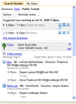
Damn dude, that makes things a whole lot simpler. Good for Google. It kinda makes me want to pack 3 meals and spend a whole day riding public transportation, just to see if I can follow directions and not get stranded.
Ok good, I just lost that urge.
Anyway, I guess this is just another reply to high gas prices, and I imagine only a first step towards encouraging people and cities to use/develop more public transit.
Update: Some quick research shows that Google added Transit a year ago on my birthday (though Atlanta wasn’t added until last month). Google? Trying to give me a surprise birthday present?! That is so, technically, sweet.
Also, they have a main Google Maps Transit page listing all the cities currently covered. Hey look, there’s Tampa, FL…
More Humor

Sumo Has Swayed Me Again

The Sumo Emperor: Fit for a King
